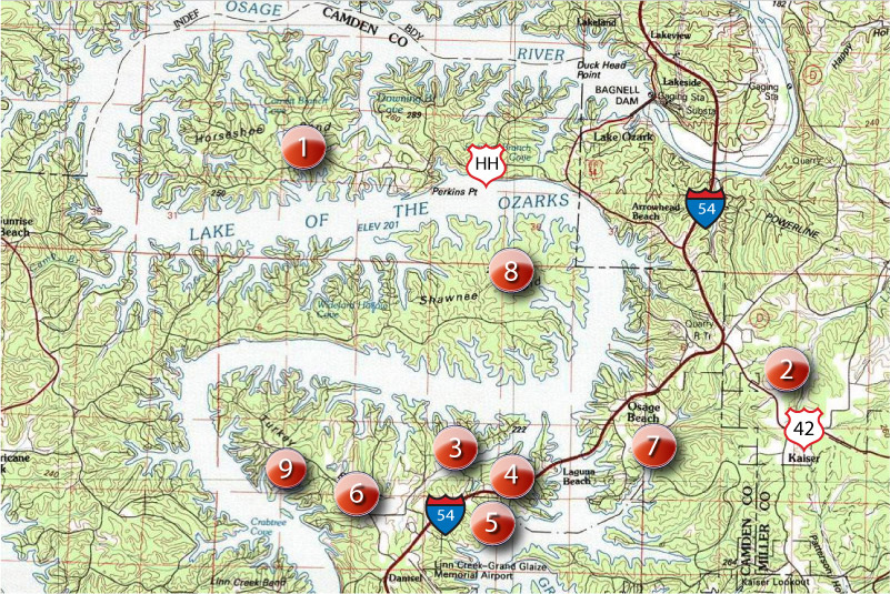
Osage Beach • Horseshoe Bend • Shawnee Bend

Please note: Some of our local hiking and biking trails are also suitable for walking and running, although the surfaces tend to be much more rugged.
DEDICATED PATHS/SIDEWALKS/TRACKS
1. Village of Four Seasons walking/biking path
Without exception, the nicest walking/biking path in the Lake area. About six miles of smooth asphalt, running along Horseshoe Bend Parkway, Bittersweet and other roads in the Village of Four Season. Since some of the path is not physically separated from the adjacent roadway, parents should be extra cautious on those sections. Parking is available at the corner of Horseshoe Bend Parkway and Bittersweet Road.
2. School of the Osage High School track
If you can stand going round and round, lap after lap, this is a great place to walk or run. The surface is rubberized, so it's also easy on the feet. And, unlike everything else in the Lake area, it's perfectly flat!
3. Dude Ranch Road walking/biking path
It's only 0.8 miles long, but the paved walking/biking path along Dude Ranch Road is included here because it's one of few dedicated paths in Osage Beach. It's (mostly) separated from the adjacent roadway, so it's pretty safe for children, too. If you're willing to get off the path, there are nearby streets where you can easily add to your walk, run or ride distance. The few hills are very gradual.
7. Osage Beach City Park
The new city park on Hatchery Road (near the outlet mall) is a work-in-progress. There are plans for walking paths, but as of this writing, there's really nothing to speak of. Hopefully, that will soon change.
LOW TRAFFIC PUBLIC ROADS
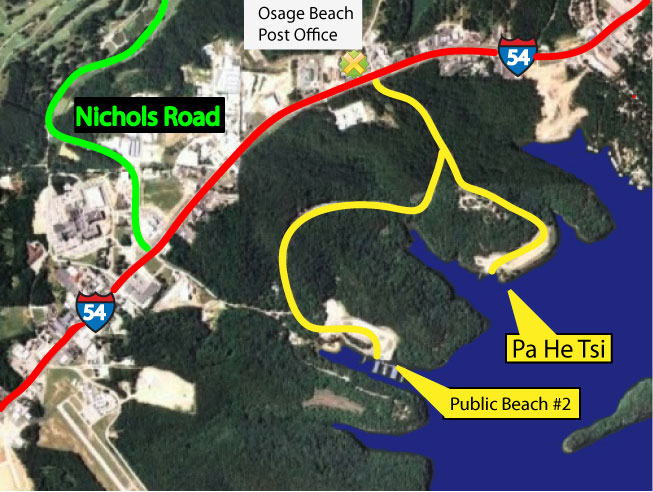
5. Public Beach #2 area
Admittedly, this isn't a very good option because it's nothing but hills--serious hills, to be sure--and since there are two boat ramps in the area, there are certain times (mostly weekends during fishing tournament season) when these roads can have lots of traffic. But, if you're a masochist for hills and able to walk/run/ride at off-peak times, it's a nice place to get your heart rate up. Here's a map to the area. (The running route is in yellow.)
6. Oak Creek
This route was found on www.mapmyrun.com. It's a 4.5-mile run on hilly streets in a mostly residential area with very light traffic.
8. Shawnee Bend
There are many subdivisions and side roads in the Porto Cima and nearby areas on Shawnee Bend that have very little traffic, and would be excellent for running and walking. However, these are best left to those living or visiting on Shawnee Bend, since crossing the toll bridge and paying $2.50 (each way) to get there to run or walk doesn't make much sense.
HIGH TRAFFIC PUBLIC ROADS
4. Highway 54
People are occasionally seen walking or running (and even cycling) on the sidewalk along Highway 54, although it's not a desirable place to do so due to the adjacent high-speed traffic just a few feet away and numerous intersections and driveways. But, it's option. It's definitely not for kids.
OTHER
9. Tan-Tar-A Resort
This route was found on www.mapmyrun.com. It's described as 4.5 miles long, very hilly and scenic. Note: Since Tan-Tar-A is only open to hotel guests and residents of Tan-Tar-A Estates, this route should only be used by such guests and residents.